South America Map Quiz
South America Map Quiz: 15 rounds. Look at each clue, pick the right answer and beat the clock. No sign-up, instant score, and every answer revealed at the end.
15 questionsMixed (easy → hard)~3 minNo timer
Updated:
If you liked this
Trending today
 Bollywood QuizBollywood
 India GK Question Answer Quiz (Indian GK)General Knowledge
 Cricket World Cup QuizSports
 सामान्य ज्ञान प्रश्न (GK in Hindi Questions)Hindi
 Guess the FlagGeography
 Current Affairs Quiz (October 2026)Current Affairs
 Friends TV Series QuizMovies & TV
 KBC क्विज़ (KBC Hindi Quiz)Hindi
 F1 Quiz (Formula 1)Sports
 Naruto QuizAnime & Games
About this South America Map quiz
This South America map quiz shows you a real locator map in every round, with one country, territory or island group shaded or circled in red. Your job is to name it, or to answer a question about it: its capital, its language, or the landmark that made it famous. The 15 rounds start with the giants everyone knows, like Brazil and Argentina, then work through the Andes and up to the tricky north-east corner where Guyana, Suriname and French Guiana sit side by side.
The quiz suits students revising world geography, travellers planning a trip, and anyone who likes a map quiz on South America that teaches as well as tests. Every answer comes with a short explanation, so even a wrong guess leaves you knowing something new. Play once to get a baseline, read the explanations, then play again a day later to see how much has stuck. Teachers can use it as a quick classroom warm-up by putting the maps on a projector.
South America has 12 independent countries plus French Guiana, which is part of France, and the Falkland Islands, a British Overseas Territory. Two countries, Bolivia and Paraguay, are landlocked. A fun fact to take away: Brazil borders every South American country except two, Chile and Ecuador.
South America Map questions with answers
Show answers
Which country is highlighted on this map of South America?
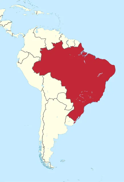
TUBS, CC BY-SA 3.0, via Wikimedia Commons - Brazil
- Argentina
- Peru
- Colombia
Answer: Brazil. Brazil covers nearly half of South America and borders every other South American country except Chile and Ecuador.
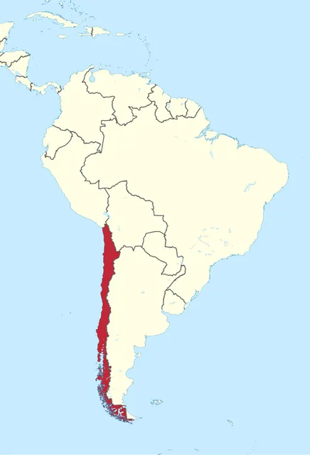
Name the long, narrow country highlighted along the Pacific coast.
TUBS, CC BY-SA 3.0, via Wikimedia Commons - Peru
- Ecuador
- Chile
- Bolivia
Answer: Chile. Chile stretches about 4,300 km from north to south but averages less than 180 km wide, squeezed between the Andes and the Pacific.
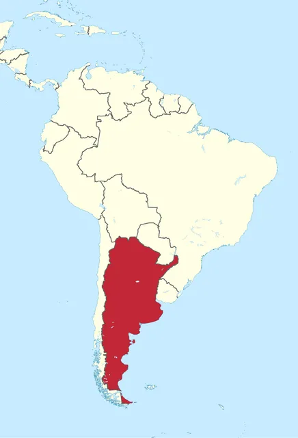
The highlighted country is the second-largest in South America. What is its capital?
TUBS, CC BY-SA 3.0, via Wikimedia Commons - Montevideo
- Buenos Aires
- Santiago
- Cordoba
Answer: Buenos Aires. This is Argentina, whose capital Buenos Aires sits on the Rio de la Plata estuary. Cordoba is its second-largest city.
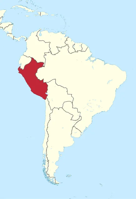
The Inca citadel of Machu Picchu lies in the highlighted country. Which country is it?
TUBS, CC BY-SA 3.0, via Wikimedia Commons - Ecuador
- Bolivia
- Colombia
- Peru
Answer: Peru. Machu Picchu was built by the Incas in the 15th century high in the Andes of Peru, and is now a UNESCO World Heritage Site.
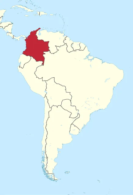
The highlighted country is the only one in South America with coastlines on both the Pacific Ocean and the Caribbean Sea. Which is it?
TUBS, CC BY-SA 3.0, via Wikimedia Commons - Venezuela
- Ecuador
- Colombia
- Guyana
Answer: Colombia. Colombia sits in the north-west corner of the continent, bordering Panama, which gives it both a Caribbean and a Pacific coast.
Angel Falls, the world's highest uninterrupted waterfall, is in the highlighted country. Name it.
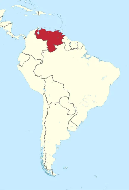
TUBS, CC BY-SA 3.0, via Wikimedia Commons - Venezuela
- Colombia
- Guyana
- Suriname
Answer: Venezuela. Angel Falls in Venezuela drops about 979 m from the edge of a flat-topped mountain called Auyan-tepui.
The highlighted country's government sits in La Paz. Which city is its constitutional capital?
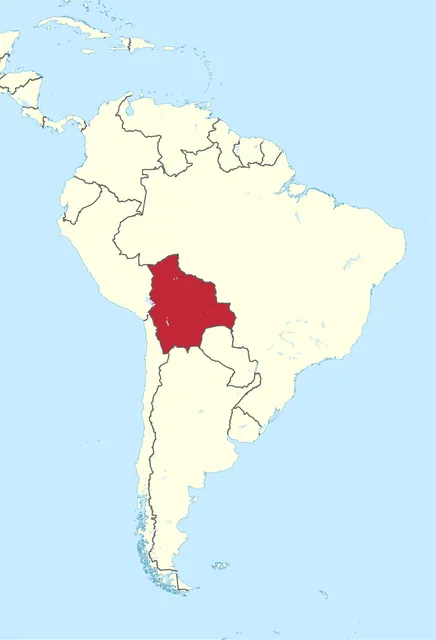
TUBS, CC BY-SA 3.0, via Wikimedia Commons - Cochabamba
- Santa Cruz
- Quito
- Sucre
Answer: Sucre. Bolivia has two capitals: Sucre is the constitutional capital and home of the supreme court, while La Paz is the seat of government.
This country is named after the imaginary line that runs through it. Which country is highlighted?
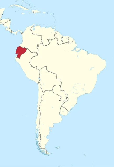
TUBS, CC BY-SA 3.0, via Wikimedia Commons - Peru
- Ecuador
- Colombia
- Bolivia
Answer: Ecuador. Ecuador is Spanish for 'equator'. The equator passes just north of its capital, Quito.
The highlighted country hosted and won the first FIFA World Cup in 1930. Which country is it?
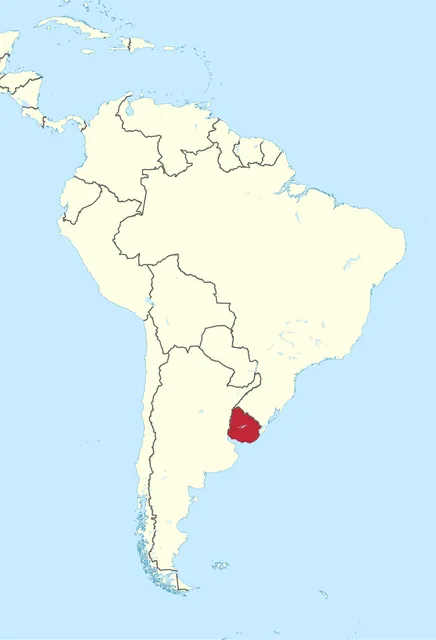
TUBS, CC BY-SA 3.0, via Wikimedia Commons - Paraguay
- Argentina
- Uruguay
- Brazil
Answer: Uruguay. Uruguay beat Argentina 4-2 in the 1930 final in Montevideo, its capital.
Besides Spanish, which Indigenous language is an official language of the highlighted landlocked country?
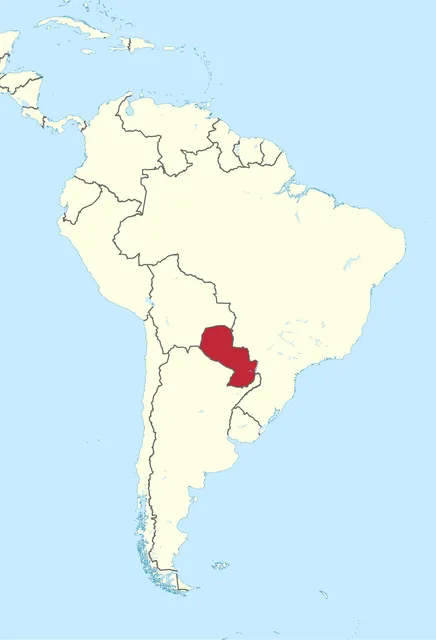
TUBS, CC BY-SA 3.0, via Wikimedia Commons - Guarani
- Quechua
- Aymara
- Mapudungun
Answer: Guarani. Paraguay's 1992 constitution made Guarani an official language alongside Spanish, and most Paraguayans speak it. Quechua and Aymara are official in Bolivia and Peru.
What is the official language of the highlighted country?
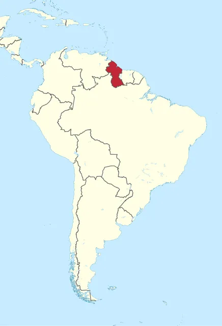
TUBS, CC BY-SA 3.0, via Wikimedia Commons - Dutch
- French
- Portuguese
- English
Answer: English. Guyana, a former British colony, is the only South American country with English as its official language. Its capital is Georgetown.
The highlighted country's official language is Dutch. What is its capital?
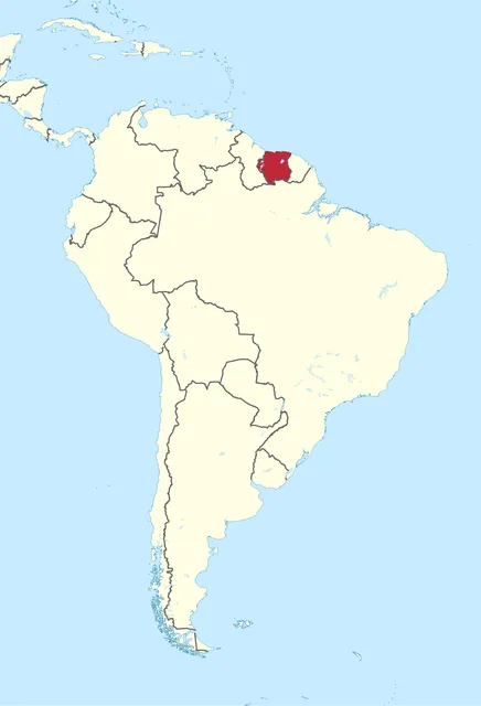
TUBS, CC BY-SA 3.0, via Wikimedia Commons - Georgetown
- Paramaribo
- Cayenne
- Caracas
Answer: Paramaribo. Suriname, the smallest independent country in South America, gained independence from the Netherlands in 1975. Paramaribo is its capital.
The highlighted territory is not an independent country. It is an overseas region of which nation?
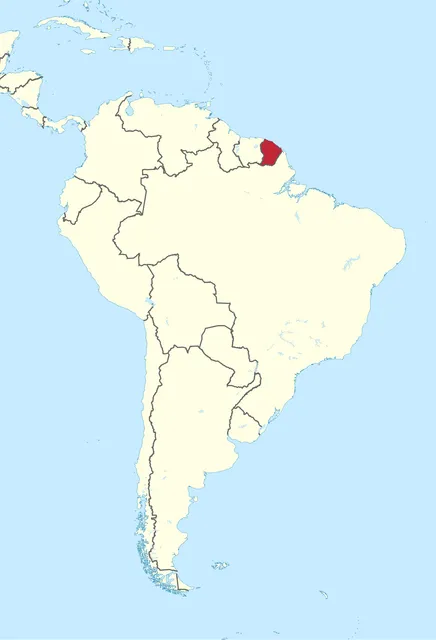
TUBS, CC BY-SA 3.0, via Wikimedia Commons - France
- Netherlands
- United Kingdom
- Portugal
Answer: France. French Guiana is part of France, so it uses the euro. Europe's main rocket launch site, the Guiana Space Centre, is at Kourou.
Which group of islands is circled on this map?
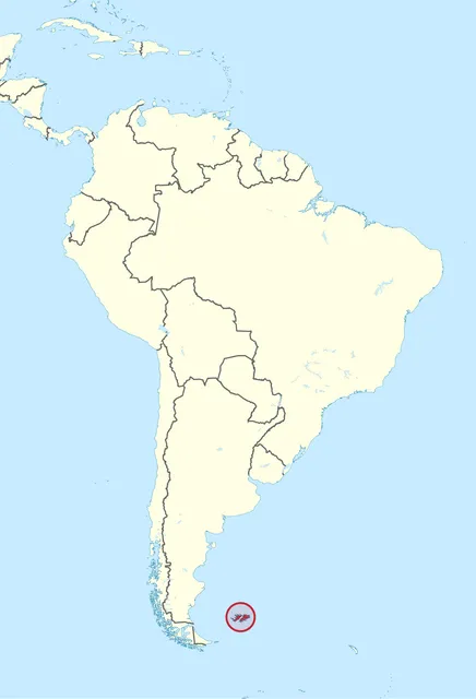
TUBS, CC BY-SA 3.0, via Wikimedia Commons - South Georgia
- Tierra del Fuego
- Falkland Islands
- Galapagos Islands
Answer: Falkland Islands. The Falkland Islands in the South Atlantic are a British Overseas Territory with Stanley as capital. Argentina claims them as the Islas Malvinas, and the two fought over them in 1982.
The circled islands, famous for giant tortoises and Charles Darwin's 1835 visit, belong to which country?
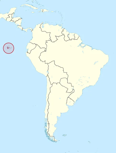
TUBS, CC BY-SA 3.0, via Wikimedia Commons - Peru
- Ecuador
- Chile
- Colombia
Answer: Ecuador. The Galapagos Islands lie about 1,000 km off the coast of Ecuador. Chile is a good guess but wrong: its famous Pacific island is Easter Island.
Frequently asked questions
Where can I find South America map questions with answers?
Right here. Play the 15 rounds above and every answer is revealed at the end with a short explanation. The full answer key also sits further down the page under the questions-with-answers section, so you can study it before or after you play.
How many questions are in this South America map quiz?
There are 15 map rounds. Most ask you to name the highlighted country or island group; the rest ask about its capital, its language or the country it belongs to. It takes only a few minutes to play.
Can I play the South America map quiz online for free without signing up?
Yes. The quiz is completely free and needs no account or login. You get an instant score at the end and can share it with friends to see who knows the continent best.
How many countries are there in South America?
South America has 12 independent countries: Argentina, Bolivia, Brazil, Chile, Colombia, Ecuador, Guyana, Paraguay, Peru, Suriname, Uruguay and Venezuela. French Guiana and the Falkland Islands are territories of France and the United Kingdom.