
US Map Quiz
US Map Quiz: 15 rounds, each with one US state highlighted on the map. Pick the right answer and beat the clock. No sign-up, instant score, every answer revealed at the end.
15 questionsMixed (easy → hard)~3 minNo timer
Updated:
If you liked this

Trending today
 Bollywood QuizBollywood
 India GK Question Answer Quiz (Indian GK)General Knowledge
 Cricket World Cup QuizSports
 सामान्य ज्ञान प्रश्न (GK in Hindi Questions)Hindi
 Guess the FlagGeography
 Current Affairs Quiz (October 2026)Current Affairs
 Friends TV Series QuizMovies & TV
 KBC क्विज़ (KBC Hindi Quiz)Hindi
 F1 Quiz (Formula 1)Sports
 Naruto QuizAnime & Games
About this US Map quiz
This US map quiz tests how well you can place the states by shape and location. Each of the 15 rounds shows a map of the United States with one state highlighted in red, and you pick the right name from four options. A few rounds add a twist, asking for the capital or a fact about the highlighted state instead.
The questions start with giants such as Texas and California and finish with smaller states that are easy to mix up, like Maryland and Vermont. It works well as a state map quiz game for teens and adults, students learning US geography, and anyone planning a trip across the country. You get your score instantly, and every answer, with a short note, is listed further down the page.
A good trick for any state quiz map is to learn the shapes in clusters. The rectangles of the West (Colorado, Wyoming and Utah with its notch), the panhandles (Oklahoma, Idaho, Nebraska and Florida) and the tiny states of the north-east become easier once you can see how they fit together. Play once, read the explanations, then try again to beat your score.
Fun fact: Michigan is the only state made of two separate peninsulas. They were only linked by road in 1957, when the five-mile Mackinac Bridge opened.
US Map questions with answers
Show answers
Which state is highlighted in red?
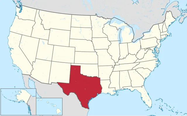
TUBS, CC BY-SA 3.0, via Wikimedia Commons - Texas
- Oklahoma
- New Mexico
- Kansas
Answer: Texas. Texas is the second-largest state by area after Alaska, and its capital is Austin.
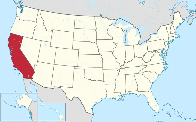
Name the highlighted state on the West Coast.
TUBS, CC BY-SA 3.0, via Wikimedia Commons - Oregon
- Nevada
- California
- Washington
Answer: California. California runs about 1,350 km along the Pacific and is the most populous state. Its capital is Sacramento.
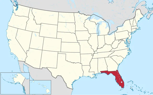
Which state is highlighted?
TUBS, CC BY-SA 3.0, via Wikimedia Commons - Georgia
- Florida
- Alabama
- South Carolina
Answer: Florida. Florida is the peninsula between the Atlantic and the Gulf. Its capital is Tallahassee, not Miami or Orlando.
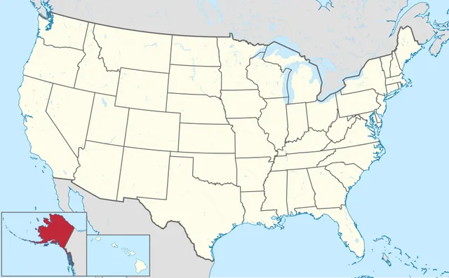
The state highlighted in the inset was bought in 1867. From which country?
TUBS, CC BY-SA 3.0, via Wikimedia Commons - Canada
- United Kingdom
- Spain
- Russia
Answer: Russia. This is Alaska. The US bought it from Russia for 7.2 million dollars, a deal critics mocked as 'Seward's Folly'.
Which north-eastern state is highlighted?
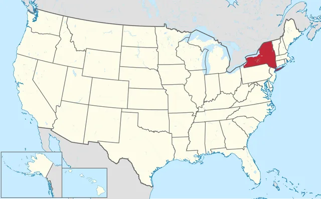
TUBS, CC BY-SA 3.0, via Wikimedia Commons - New York
- Pennsylvania
- Vermont
- New Jersey
Answer: New York. New York stretches from the Great Lakes to the Atlantic. Its capital is Albany, up the Hudson River from New York City.
The highlighted state is made of two peninsulas. Which state is it?
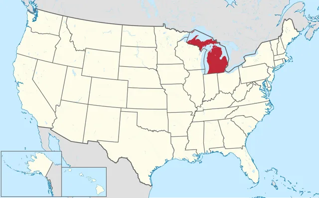
TUBS, CC BY-SA 3.0, via Wikimedia Commons - Wisconsin
- Minnesota
- Michigan
- Ohio
Answer: Michigan. Michigan's Upper and Lower Peninsulas are joined by the Mackinac Bridge, and the Lower Peninsula is famously shaped like a mitten.
This boot-shaped state is divided into parishes instead of counties. Which is it?
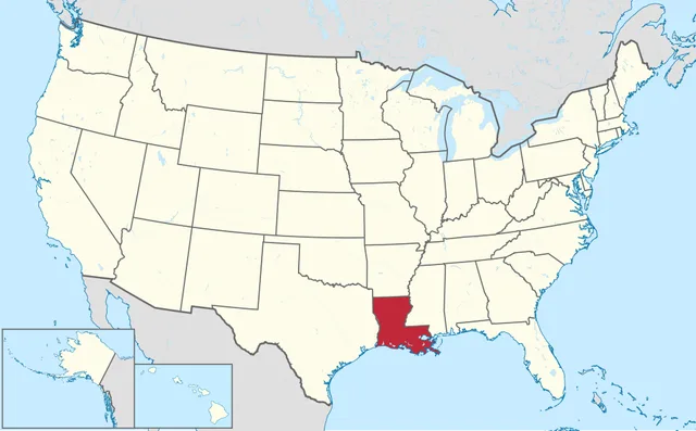
TUBS, CC BY-SA 3.0, via Wikimedia Commons - Mississippi
- Arkansas
- Alabama
- Louisiana
Answer: Louisiana. Louisiana uses parishes, a legacy of French and Spanish rule. The Mississippi River meets the Gulf here, south of New Orleans.
Spot the panhandle. Which state is highlighted?
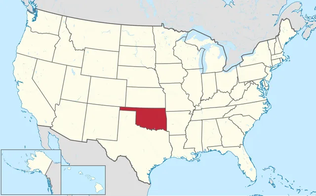
TUBS, CC BY-SA 3.0, via Wikimedia Commons - Kansas
- Oklahoma
- Arkansas
- Missouri
Answer: Oklahoma. Oklahoma's thin panhandle runs west between Kansas and Texas. Its capital is Oklahoma City.
Two western states are near-perfect rectangles. Which one is highlighted here?
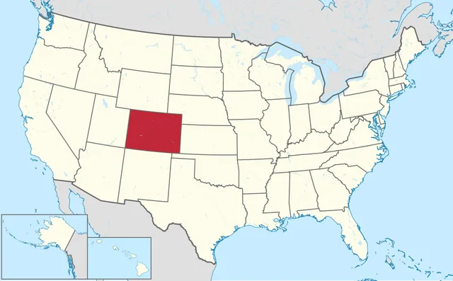
TUBS, CC BY-SA 3.0, via Wikimedia Commons - Colorado
- Wyoming
- Kansas
- Utah
Answer: Colorado. Colorado is the southern rectangle, bordering New Mexico. Wyoming is the one to its north. Colorado's capital, Denver, is the 'Mile High City'.
What is the capital of the long, narrow state highlighted here?
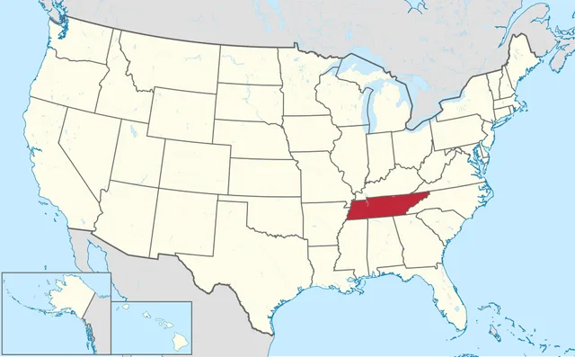
TUBS, CC BY-SA 3.0, via Wikimedia Commons - Memphis
- Nashville
- Knoxville
- Louisville
Answer: Nashville. The state is Tennessee and its capital is Nashville, the home of country music. Memphis, on the Mississippi, is famous too but is not the capital.
Which north-western state is highlighted?
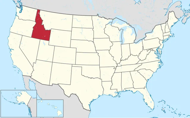
TUBS, CC BY-SA 3.0, via Wikimedia Commons - Montana
- Oregon
- Idaho
- Nevada
Answer: Idaho. Idaho's narrow northern panhandle reaches up to the Canadian border. The state is famous for potatoes and its capital is Boise.
Which state, with a notch cut from one corner, is highlighted?
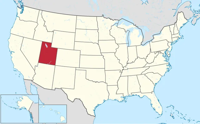
TUBS, CC BY-SA 3.0, via Wikimedia Commons - Nevada
- Arizona
- Wyoming
- Utah
Answer: Utah. Utah is a rectangle with its north-east corner taken by Wyoming. Its capital is Salt Lake City.
The highlighted state is the only one with a single-chamber legislature. Which is it?
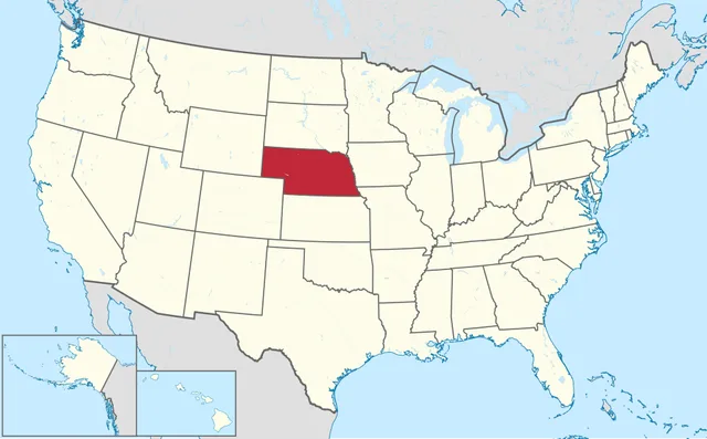
TUBS, CC BY-SA 3.0, via Wikimedia Commons - Nebraska
- Kansas
- Iowa
- South Dakota
Answer: Nebraska. Nebraska has had a unicameral legislature since 1937. Every other state has a two-house system.
Harder now. Which small state wrapped around the Chesapeake Bay is highlighted?
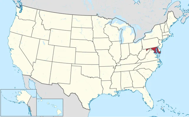
TUBS, CC BY-SA 3.0, via Wikimedia Commons - Delaware
- Virginia
- Maryland
- New Jersey
Answer: Maryland. Maryland almost splits in two around the Chesapeake Bay. Its capital is Annapolis, and it borders Washington, DC.
Final one: which New England state is highlighted?
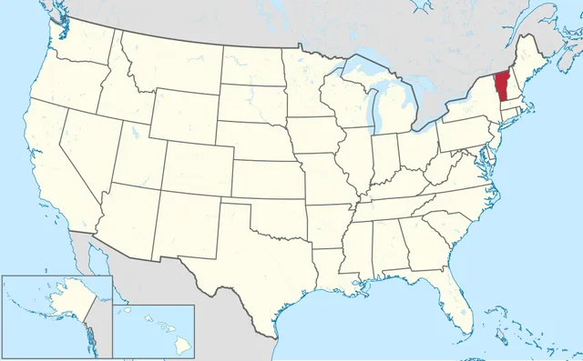
TUBS, CC BY-SA 3.0, via Wikimedia Commons - New Hampshire
- Vermont
- Maine
- Massachusetts
Answer: Vermont. Vermont is the only New England state without a coastline. Its capital, Montpelier, is the least populous state capital.
Frequently asked questions
Where can I find US map quiz questions with answers?
The answer key on this page lists all 15 highlighted states with the correct answer and a short explanation. Play the quiz first, then open the answers to see which states you missed.
How many questions are in this US Map Quiz?
There are 15 map rounds, each showing one highlighted state, ordered from easy to hard. Most people finish in three to four minutes.
Can I play the US Map Quiz online for free without signing up?
Yes. This state map quiz is free and needs no login or app. It runs in any browser on a phone or computer, and you can share your score to challenge friends.