
Americas Map Quiz
Americas Map Quiz: 15 rounds. Look at each clue, pick the right answer and beat the clock. No sign-up, instant score, and every answer revealed at the end.
15 questionsMixed (easy → hard)~3 minNo timer
Updated:
If you liked this
Trending today
 Bollywood QuizBollywood
 India GK Question Answer Quiz (Indian GK)General Knowledge
 Cricket World Cup QuizSports
 सामान्य ज्ञान प्रश्न (GK in Hindi Questions)Hindi
 Guess the FlagGeography
 Current Affairs Quiz (October 2026)Current Affairs
 Friends TV Series QuizMovies & TV
 KBC क्विज़ (KBC Hindi Quiz)Hindi
 F1 Quiz (Formula 1)Sports
 Naruto QuizAnime & Games
About this Americas Map quiz
This map quiz of the Americas covers North, Central and South America plus the Caribbean in 15 rounds. Each round shows a map with one country highlighted in red. You name the country, or answer a quick question about it, from four options. It opens with big, familiar shapes like Canada and Brazil and ends with smaller countries that many people struggle to place, such as Paraguay and Suriname.
The Americas map quiz suits teens and adults, students of world geography, and travellers planning a trip across the region. Each answer comes with a short explanation that adds a fact worth remembering, from the Panama Canal to the first football World Cup. Your score appears as soon as you finish, and the full answer key is listed lower on this page.
To improve, learn the countries in groups. Down the Pacific side of South America run Colombia, Ecuador, Peru and Chile. Across the north coast are Venezuela, Guyana and Suriname. In the middle are the two landlocked countries, Bolivia and Paraguay. Play once, read the notes, then play again a day later to see how many stick.
Fun fact: Brazil borders every country in South America except two, Chile and Ecuador.
Americas Map questions with answers
Show answers
Which country is highlighted in red?
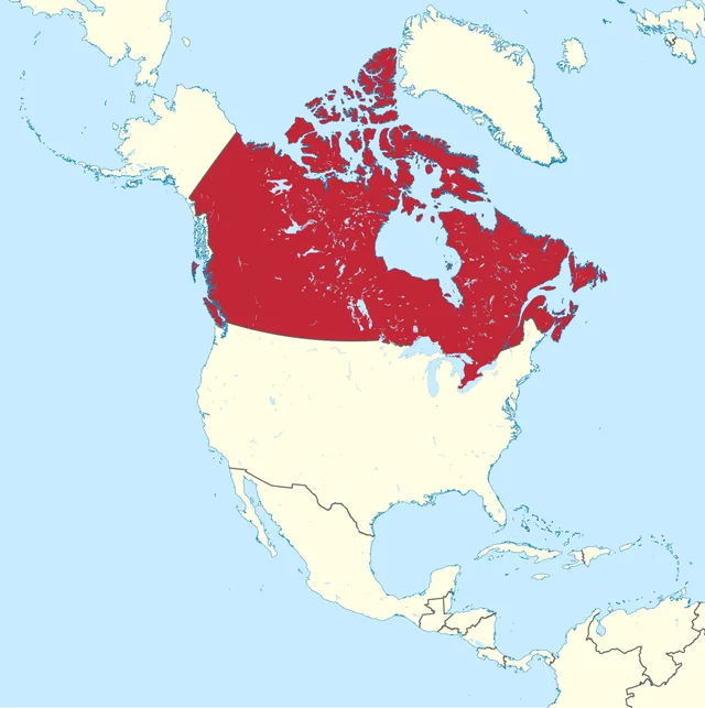
TUBS, CC BY-SA 3.0, via Wikimedia Commons - United States
- Canada
- Greenland
- Russia
Answer: Canada. Canada is the second-largest country in the world by area, after Russia. Its capital is Ottawa.
Name the highlighted country.
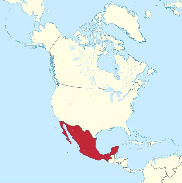
TUBS, CC BY-SA 3.0, via Wikimedia Commons - Guatemala
- Cuba
- United States
- Mexico
Answer: Mexico. Mexico links the US to Central America. Mexico City, its capital, is built on the drained bed of Lake Texcoco, where the Aztecs founded Tenochtitlan.
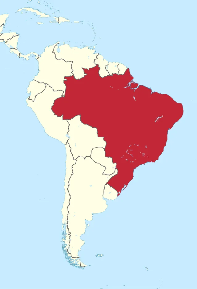
What is the main language of the highlighted country?
TUBS, CC BY-SA 3.0, via Wikimedia Commons - Portuguese
- Spanish
- French
- English
Answer: Portuguese. This is Brazil, the largest country in South America and the only one where Portuguese is the main language.
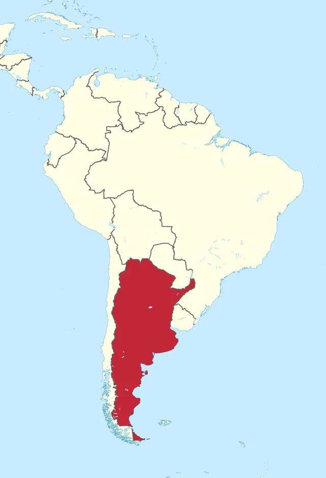
Which South American country is highlighted?
TUBS, CC BY-SA 3.0, via Wikimedia Commons - Chile
- Uruguay
- Argentina
- Paraguay
Answer: Argentina. Argentina is home to Aconcagua, the highest mountain in the Americas at about 6,960 m. Its capital is Buenos Aires.
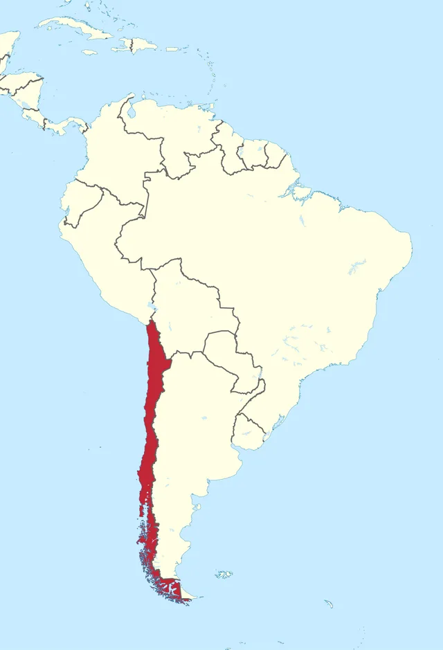
Which country is the long, narrow strip highlighted here?
TUBS, CC BY-SA 3.0, via Wikimedia Commons - Chile
- Peru
- Argentina
- Ecuador
Answer: Chile. Chile is about 4,300 km long but on average less than 180 km wide, squeezed between the Andes and the Pacific.
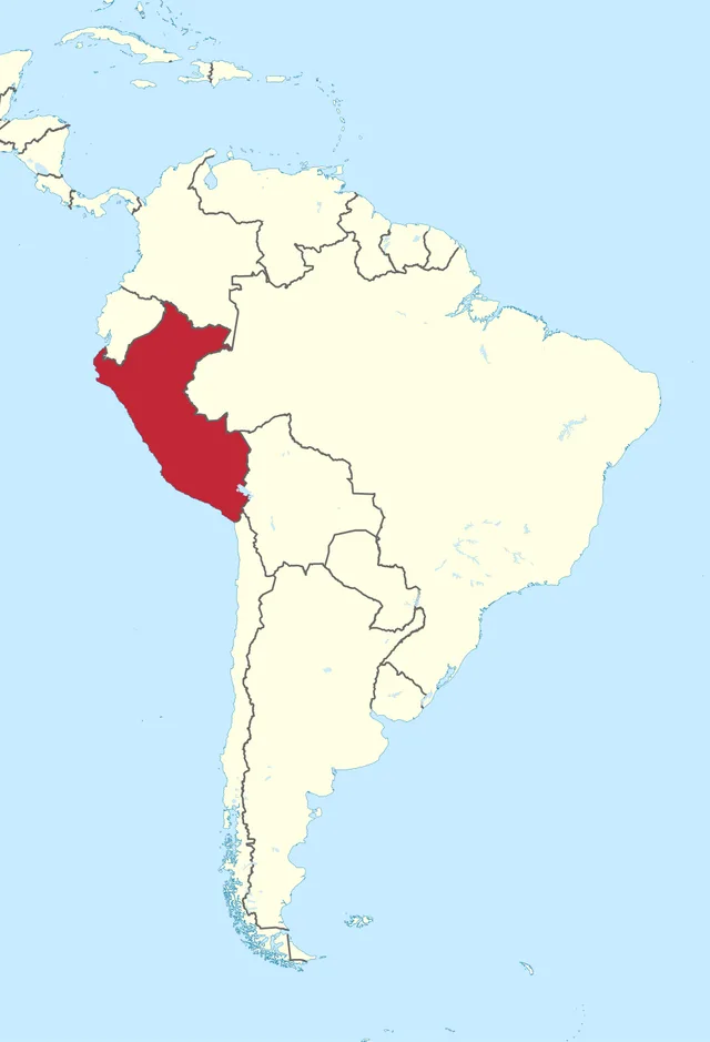
The Inca citadel of Machu Picchu is in the highlighted country. Which one?
TUBS, CC BY-SA 3.0, via Wikimedia Commons - Bolivia
- Peru
- Colombia
- Ecuador
Answer: Peru. Machu Picchu stands high in Peru's Andes, near Cusco, the old Inca capital. Peru's capital today is Lima.
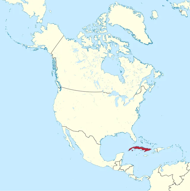
Which Caribbean island country is highlighted?
TUBS, CC BY-SA 3.0, via Wikimedia Commons - Jamaica
- Haiti
- Dominican Republic
- Cuba
Answer: Cuba. Cuba is the largest island in the Caribbean, lying just south of Florida. Its capital is Havana.
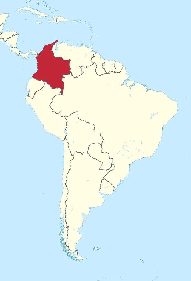
The highlighted country is the only one in South America with both a Pacific and a Caribbean coast. Name it.
TUBS, CC BY-SA 3.0, via Wikimedia Commons - Venezuela
- Ecuador
- Colombia
- Panama
Answer: Colombia. Colombia faces the Caribbean to the north and the Pacific to the west. Panama has both coasts too, but it is in Central America.
This landlocked country has two capitals, La Paz and Sucre. Which is it?
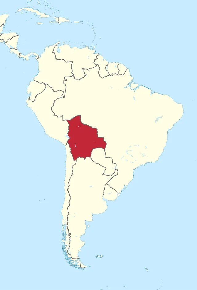
TUBS, CC BY-SA 3.0, via Wikimedia Commons - Bolivia
- Paraguay
- Ecuador
- Peru
Answer: Bolivia. Bolivia's government sits in La Paz, while Sucre is the constitutional capital. It lost its coast to Chile in the War of the Pacific (1879-84).
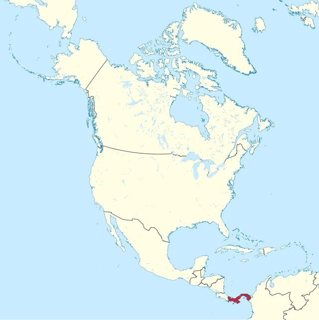
Which country, famous for a canal linking two oceans, is highlighted?
TUBS, CC BY-SA 3.0, via Wikimedia Commons - Costa Rica
- Panama
- Nicaragua
- Honduras
Answer: Panama. The Panama Canal opened in 1914 and lets ships cross between the Atlantic and Pacific without sailing round South America.
The highlighted country is named after an imaginary line. Which is it?
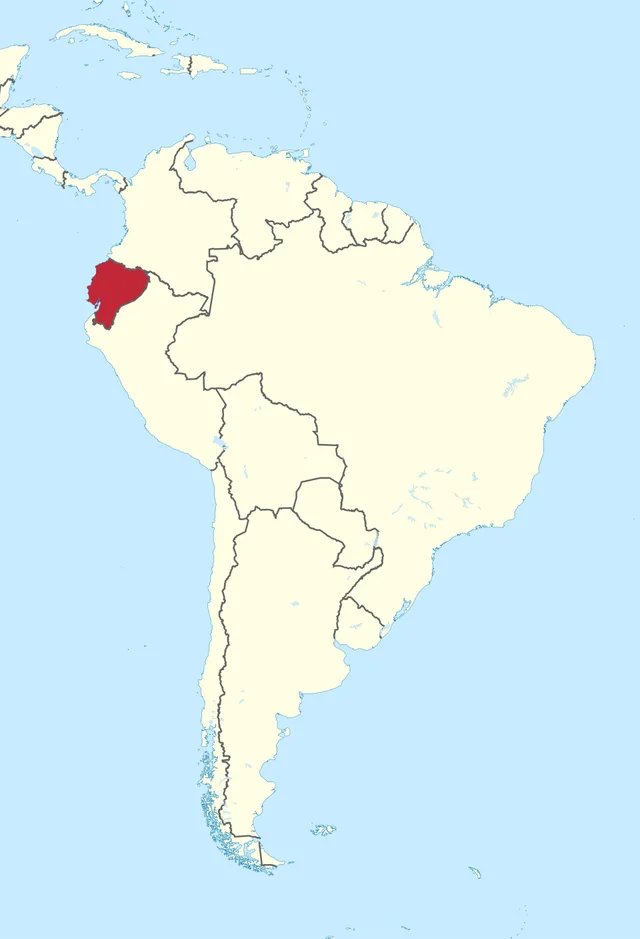
TUBS, CC BY-SA 3.0, via Wikimedia Commons - Colombia
- Peru
- Ecuador
- Venezuela
Answer: Ecuador. Ecuador is Spanish for 'equator', which crosses the country just north of Quito. The Galapagos Islands also belong to it.
Which landlocked country is highlighted?
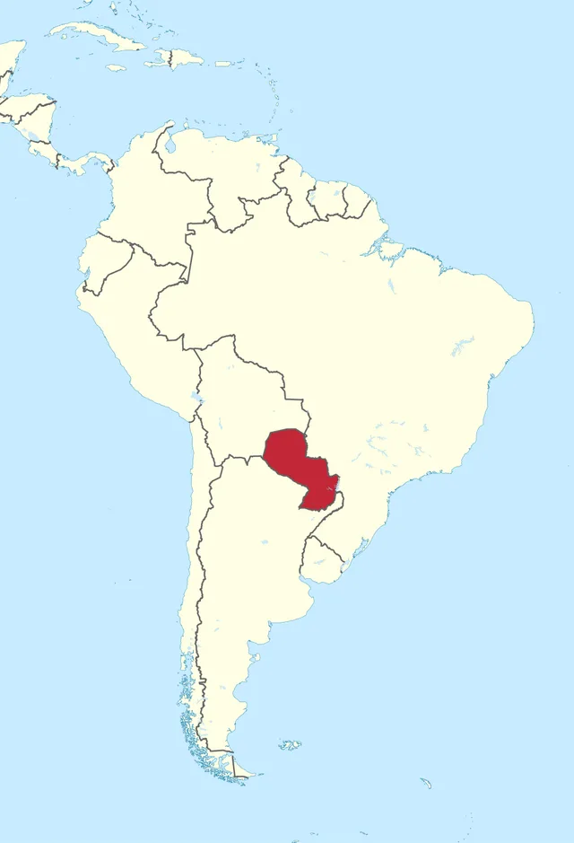
TUBS, CC BY-SA 3.0, via Wikimedia Commons - Uruguay
- Bolivia
- Suriname
- Paraguay
Answer: Paraguay. Paraguay and Bolivia are South America's only landlocked countries. Paraguay's capital is Asuncion, on the Paraguay River.
Which Central American country, home to the Maya city of Tikal, is highlighted?
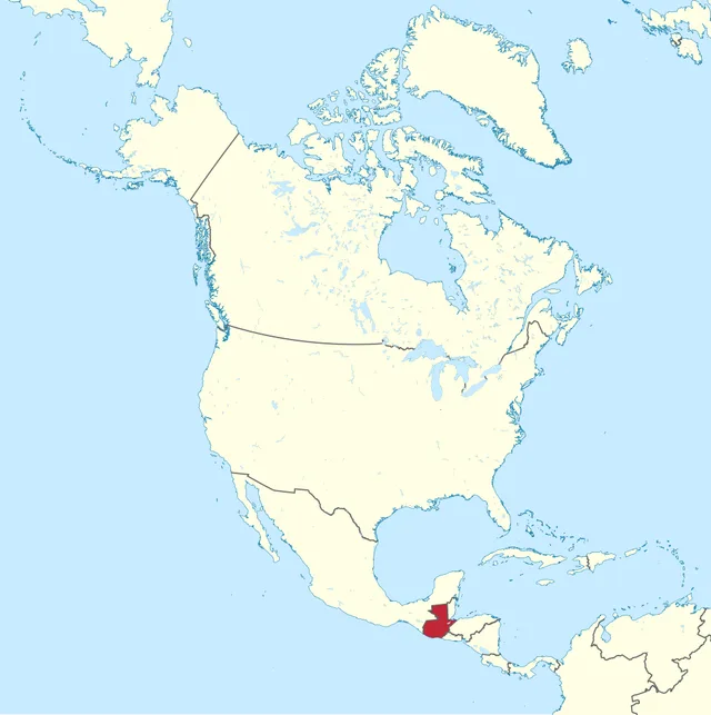
TUBS, CC BY-SA 3.0, via Wikimedia Commons - Honduras
- Guatemala
- Belize
- El Salvador
Answer: Guatemala. Guatemala borders Mexico to the north. Tikal, deep in its rainforest, was one of the greatest Maya cities.
The highlighted country hosted and won the first FIFA World Cup in 1930. Which is it?
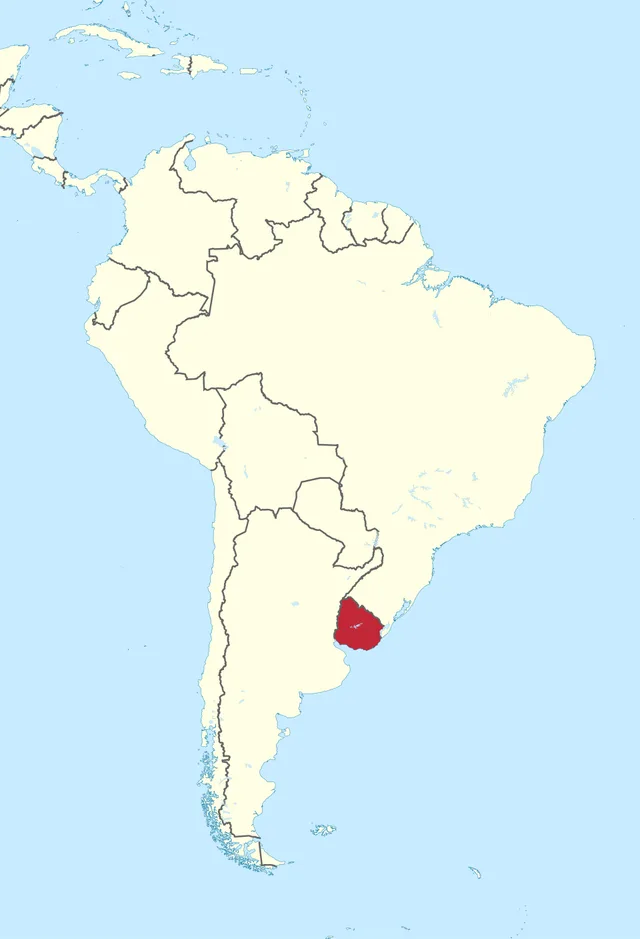
TUBS, CC BY-SA 3.0, via Wikimedia Commons - Uruguay
- Argentina
- Brazil
- Paraguay
Answer: Uruguay. Uruguay beat Argentina 4-2 in the 1930 final in Montevideo, its capital.
Final round: the highlighted country's official language is Dutch. Which is it?
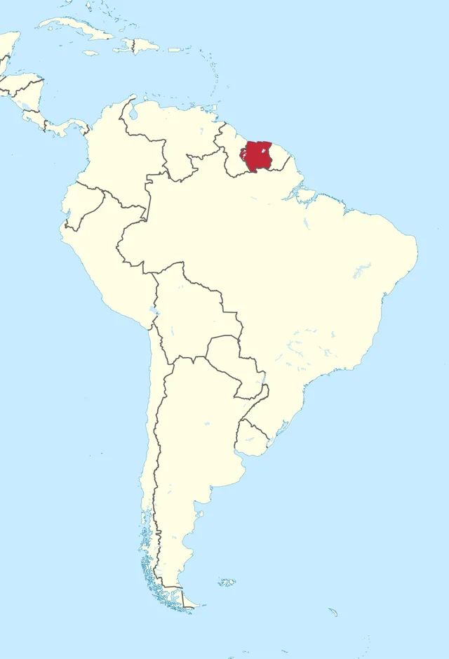
TUBS, CC BY-SA 3.0, via Wikimedia Commons - Guyana
- Venezuela
- Suriname
- Colombia
Answer: Suriname. Suriname, a former Dutch colony, is the smallest independent country in South America. Guyana next door speaks English.
Frequently asked questions
Where can I find Americas Map questions with answers?
The answer key on this page lists all 15 highlighted countries with the right answer and a short explanation. Finish the quiz first, then open the answers to check the ones you missed.
How many questions are in this Americas Map quiz?
There are 15 rounds: some from North and Central America and the Caribbean, most from South America. They get harder as you go, and most players finish in about four minutes.
Can I play the Americas Map quiz online for free without signing up?
Yes. It is free, with no sign-up or download, and works on any phone or computer. Your score shows instantly and you can share it to challenge friends.