
Asia Map Quiz
Asia Map Quiz: 15 rounds. Look at each clue, pick the right answer and beat the clock. No sign-up, instant score, and every answer revealed at the end.
15 questionsMixed (easy → hard)~3 minNo timer
Updated:
If you liked this
Trending today
 Bollywood QuizBollywood
 India GK Question Answer Quiz (Indian GK)General Knowledge
 Cricket World Cup QuizSports
 सामान्य ज्ञान प्रश्न (GK in Hindi Questions)Hindi
 Guess the FlagGeography
 Current Affairs Quiz (October 2026)Current Affairs
 Friends TV Series QuizMovies & TV
 KBC क्विज़ (KBC Hindi Quiz)Hindi
 F1 Quiz (Formula 1)Sports
 Naruto QuizAnime & Games
About this Asia Map quiz
This Asia map quiz puts 15 countries on the map for you to name, from Japan and Saudi Arabia to the trickier corners of Central and South-East Asia. Every round shows a map of Asia with one country highlighted in red and four options to choose from. Some rounds add a twist, asking for a capital or a record the country holds.
It works as a quick map quiz of Asia for teens and adults, students revising world geography, and quiz fans who want a challenge beyond the usual big names. East Asia gets plenty of attention too, with Japan, South Korea and Mongolia all on the board. Your score appears instantly, and every answer, with a short explanation, is listed further down the page, so it doubles as a blank map of Asia quiz with answers for revision.
The easiest way to improve is to learn Asia in regions: the Middle East, Central Asia with its many countries ending in '-stan', South Asia, South-East Asia and East Asia. Play once, read the notes on the ones you missed, then try again.
Fun fact: Uzbekistan is one of only two doubly landlocked countries in the world. The other is Liechtenstein, in Europe.
Asia Map questions with answers
Show answers
Which East Asian island country is highlighted in red?
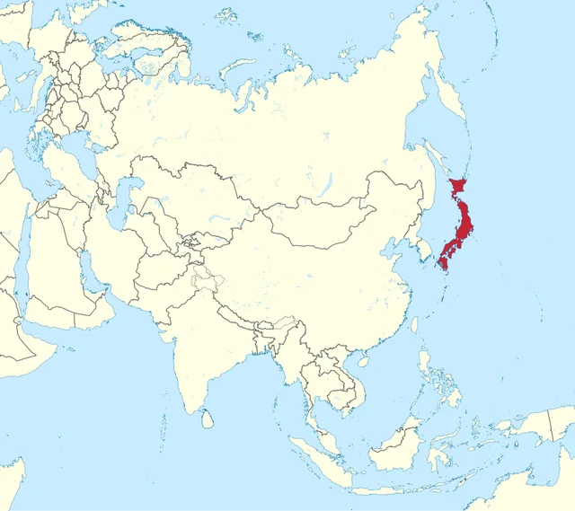
TUBS, CC BY-SA 3.0, via Wikimedia Commons - Philippines
- South Korea
- Indonesia
- Japan
Answer: Japan. Japan's four largest islands are Honshu, Hokkaido, Kyushu and Shikoku, and it has thousands of smaller ones. Its capital is Tokyo.
Name the highlighted country, which covers most of a desert peninsula.
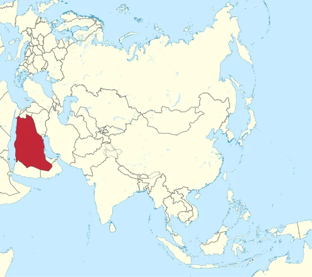
TUBS, CC BY-SA 3.0, via Wikimedia Commons - Iraq
- Saudi Arabia
- Iran
- Yemen
Answer: Saudi Arabia. Saudi Arabia covers about four-fifths of the Arabian Peninsula and has no permanent rivers at all. Its capital is Riyadh.
Which country, spread across more than 17,000 islands, is highlighted?
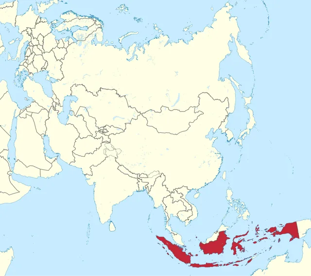
TUBS, CC BY-SA 3.0, via Wikimedia Commons - Indonesia
- Philippines
- Malaysia
- Papua New Guinea
Answer: Indonesia. Indonesia is the world's largest archipelago country and the most populous Muslim-majority nation.
What is the capital of the highlighted country, squeezed between Russia and China?
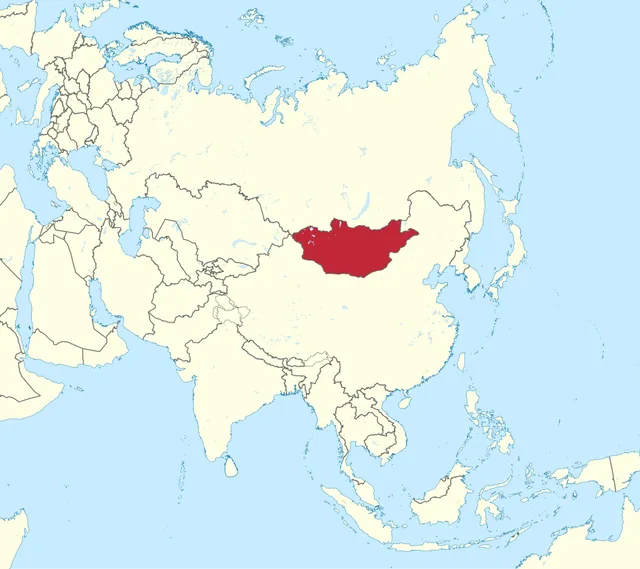
TUBS, CC BY-SA 3.0, via Wikimedia Commons - Astana
- Bishkek
- Ulaanbaatar
- Tashkent
Answer: Ulaanbaatar. The country is Mongolia. Ulaanbaatar is the coldest national capital in the world, averaging close to 0 degrees C over a year.
The highlighted country is the only one in South-East Asia never colonised by a European power. Which is it?
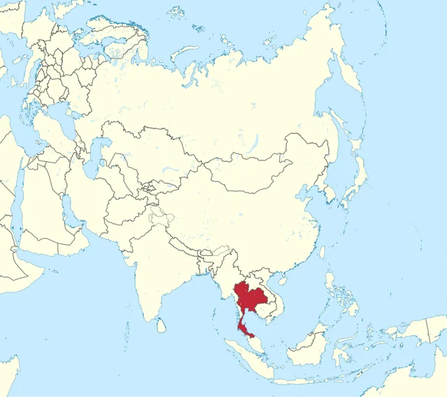
TUBS, CC BY-SA 3.0, via Wikimedia Commons - Thailand
- Myanmar
- Cambodia
- Vietnam
Answer: Thailand. Thailand, once called Siam, kept its independence while its neighbours were ruled by Britain and France. Its capital is Bangkok.
Which East Asian country is highlighted?
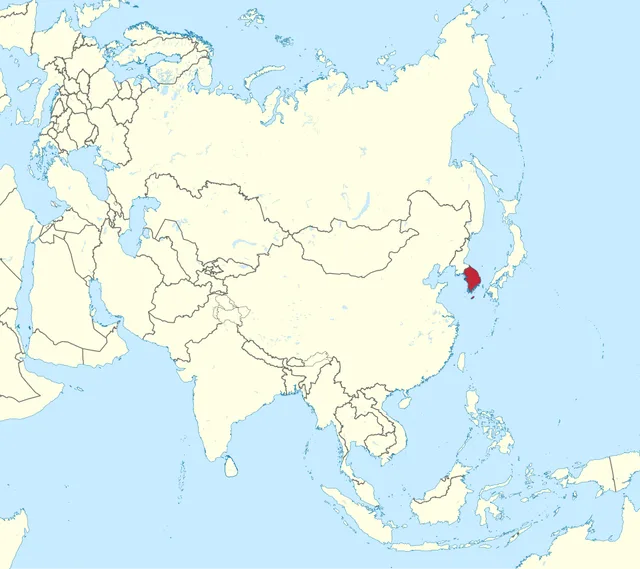
TUBS, CC BY-SA 3.0, via Wikimedia Commons - North Korea
- Japan
- South Korea
- Mongolia
Answer: South Korea. South Korea covers the southern half of the Korean Peninsula. Its only land border is with North Korea, and its capital is Seoul.
Which S-shaped country is highlighted?
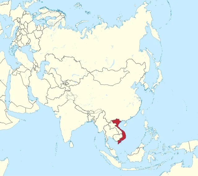
TUBS, CC BY-SA 3.0, via Wikimedia Commons - Laos
- Vietnam
- Cambodia
- Malaysia
Answer: Vietnam. Vietnam stretches about 1,650 km from north to south along the South China Sea. Its capital is Hanoi, though Ho Chi Minh City is larger.
The highlighted country was known internationally as Persia until 1935. Which is it?
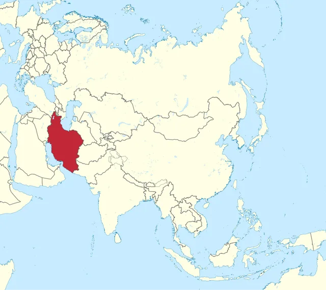
TUBS, CC BY-SA 3.0, via Wikimedia Commons - Iraq
- Afghanistan
- Turkey
- Iran
Answer: Iran. Iran asked other countries to use its own name, Iran, from 1935. Its capital is Tehran.
Which island nation is highlighted?
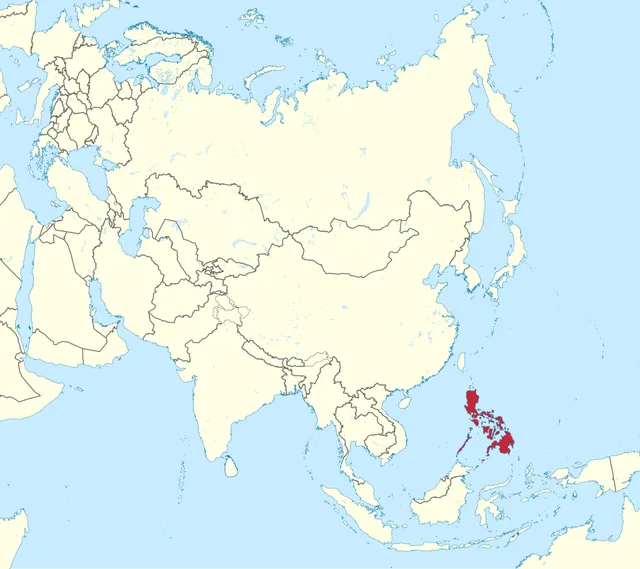
TUBS, CC BY-SA 3.0, via Wikimedia Commons - Philippines
- Japan
- Indonesia
- Brunei
Answer: Philippines. The Philippines has more than 7,000 islands, with Luzon and Mindanao the largest. Its capital is Manila.
The highlighted country is the largest landlocked country on Earth. Name it.
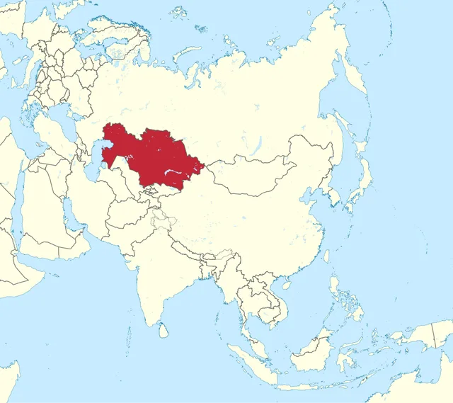
TUBS, CC BY-SA 3.0, via Wikimedia Commons - Mongolia
- Afghanistan
- Kazakhstan
- Uzbekistan
Answer: Kazakhstan. Kazakhstan is the ninth-largest country overall and the biggest with no ocean coast. Mongolia is the second-largest landlocked country.
Which island country is highlighted?
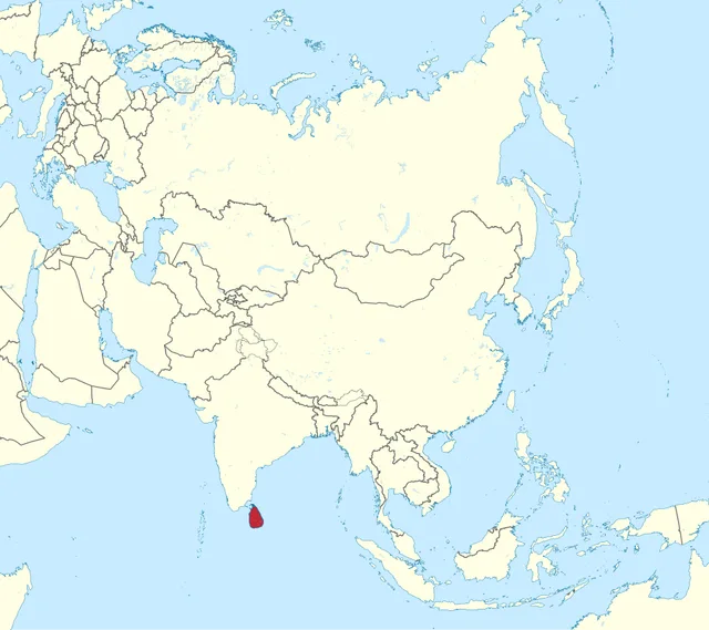
TUBS, CC BY-SA 3.0, via Wikimedia Commons - Maldives
- Sri Lanka
- Bangladesh
- Myanmar
Answer: Sri Lanka. Sri Lanka is separated from India by the narrow Palk Strait. Colombo is its main city; Sri Jayawardenepura Kotte is the official capital.
Which country, once called Burma, is highlighted?
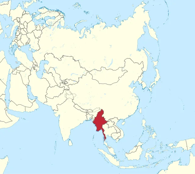
TUBS, CC BY-SA 3.0, via Wikimedia Commons - Thailand
- Bangladesh
- Laos
- Myanmar
Answer: Myanmar. Myanmar borders India, Bangladesh, China, Laos and Thailand. Its capital moved from Yangon to Naypyidaw in the mid-2000s.
The highlighted country is split between a mainland peninsula and the north of Borneo. Which is it?
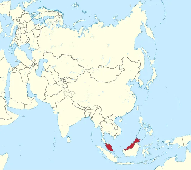
TUBS, CC BY-SA 3.0, via Wikimedia Commons - Malaysia
- Indonesia
- Brunei
- Singapore
Answer: Malaysia. Malaysia has two parts, Peninsular Malaysia and Sabah and Sarawak on Borneo, divided by the South China Sea. Its capital is Kuala Lumpur.
Which is the only landlocked country in South-East Asia, highlighted here?
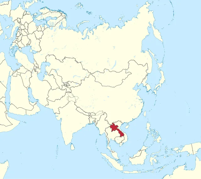
TUBS, CC BY-SA 3.0, via Wikimedia Commons - Cambodia
- Laos
- Myanmar
- Vietnam
Answer: Laos. Laos has no coast. The Mekong River forms much of its border with Thailand, and its capital is Vientiane.
Final round: the highlighted country is doubly landlocked, surrounded only by other landlocked countries. Which is it?
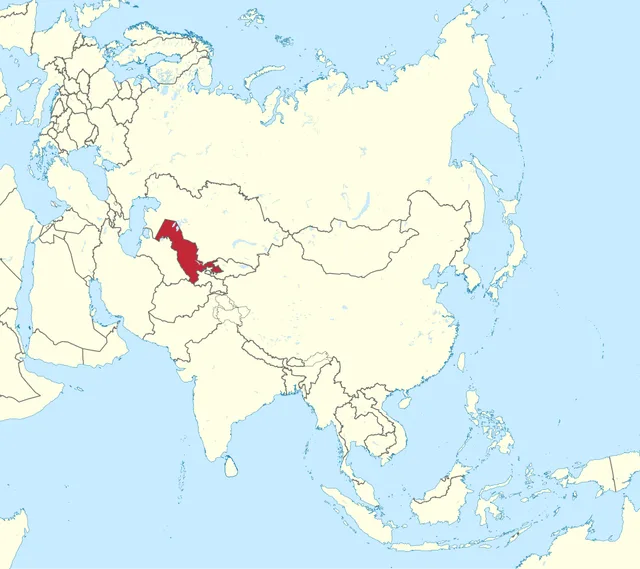
TUBS, CC BY-SA 3.0, via Wikimedia Commons - Turkmenistan
- Kyrgyzstan
- Uzbekistan
- Tajikistan
Answer: Uzbekistan. Uzbekistan and Liechtenstein are the world's only doubly landlocked countries. From Uzbekistan you must cross at least two borders to reach the sea.
Frequently asked questions
Where can I find Asia Map questions with answers?
This page has them. All 15 highlighted countries are listed in the answer key below the quiz, each with the correct answer and a short explanation. Play first, then check your answers.
How many questions are in this Asia Map quiz?
There are 15 rounds, ordered from easy to hard, covering the Middle East, Central Asia, South Asia, South-East Asia and East Asia. Most players finish in about four minutes.
Can I play the Asia Map quiz online for free without signing up?
Yes. The quiz is free, with no login or download, and works on any phone, tablet or computer. You get your score instantly and can share it with friends.